John Crawfurd's description of the old Malay Wall of Singapore
Sunday, 3 February 18221
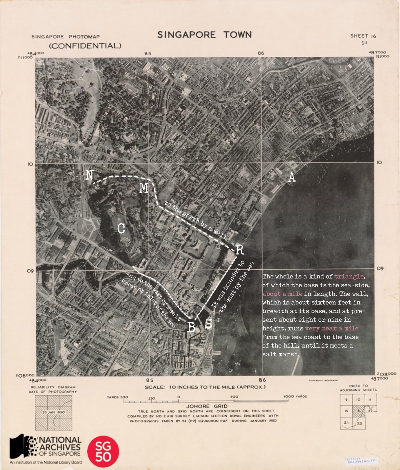
I walked this morning round the walls and limits of the ancient town of Singapore, for such in reality had been the site of our modern settlement.
It was bounded to the east by the sea (BR), to the north by a wall (RMN), and to the west by a salt creek or inlet of the sea (NCB). The inclosed space is a plain, ending in a hill of considerable extent, and 150 feet in height. The whole is a kind of triangle, of which the base is the sea-side, about a mile2 in length
The wall, which is about 16 feet in breadth at its base, and at present about 8 or 9 in height, runs very near a mile from the sea coast to the base of the hill, until it meets a salt marsh. As long as it continues in the plain, it is skirted by a little rivulet running at the foot of it, and forming a kind of moat; and where it attains the elevated side of the hill, there are apparent the remains of a dry ditch.
On the western side, which extends from the termination of the wall to the sea, the distance, like that of the northern side, is very near a mile. This last has the natural and strong defence of a salt marsh, overflown at high-water, and of a deep and broad creek.
In the wall there are no traces of embrasures or loop-holes; and neither on the sea side, nor on that skirted by the creek and marsh, is there any appearance whatever of artificial defences.
We may conclude3 from these circumstances, that the works of Singapore were not intended against fire-arms, or an attack by sea; or that if that latter, the inhabitants considered themselves strong in their naval forces, and therefore thought any other defences in that quarter superfluous.
- J. Crawford (1828) Journal of an embassy from the Governor-General of India to the Courts of Siam and Cochin China; exhibiting a view of the actual state of those kingdoms, Henry Colburn, London, pp. 44 - 45.
- The length of the shoreline estimated by Crawfurd is probably incorrect since the length of BR is approximately \(\frac{1}{2}\)-mile. In order to match Crawfurd's description, we need to extend the shoreline to Point A.
From Point A, we can then draw a nice straight line to the base of the hill, N. If this reconstruction is correct, then AMN should form the line of the old Wall. Since RMN is the actual line of the old Wall, Crawfurd's original description must be incorrect.
- Crawfurd concluded in the final paragraph that the old Wall is not a strong fortification and was unlikely to resist attack by enemies.
If this is true, then the strong Temasek fortication mentioned by Wang Dayuan 汪大淵 in his An abridged record of insular natives 島夷志略, which was able to resist the Siamese attack for a month, could be a reference to the palisade of a 700-year-old maritime town situated between Pulai River and Tebrau River.
近年,以七十餘艘來侵單馬錫,攻打城池,一月不下。本處閉關而守,不敢與爭。遇爪哇使臣經過,暹人聞知乃遁,遂掠昔里而歸。
至正己丑夏五月,降於羅斛。
Following Rockhill (1915), Wang's account can be translated as: . . . in recent years they came with seventy odd junks and raided Temasik and attacked the city moat. (The town) resisted for a month, the place having closed its gates and defending itself, and they not daring to assault it. It happened just then that an Imperial envoy was passing by Temasik, so the Suphanburi Siamese drew off and hid, after plundering Tanah Seri 昔里.
Since the Gregorian bracket matching 至正己丑夏五月 was 18 May 1349 to 15 June 1349, it is reasonable to suppose that the attack on Temasik occured between 1330 and 1349, and most likely towards the end of the calendrical spectrum since Wang used the word ‘近年' and Temasik was still a Majapahit polity at the time when Wang wrote the Siam entry in his travelogue.

Luóhú 羅斛 is the Chinese word for Lavo or Lopburi. Wang's last sentence essentially means that Suphanburi was defeated by Lavo in the middle of 1349. The Siam-Lavo merger resulted in the Ayutthaya kingdom, its first monarch was Ramathibodi I (b. 1314, d. 1369). The Indic name of Lavo is Lavapura (the City of the Son of Rama and Sita) if we assign Sanskrit value (लव) to the word ‘lava'. The phonetic value of 羅斛 is preserved in Lahore (لاہور), a city that is also named after Lava.
W. W. Rockhill (1915) Notes on the relations and trade of China with the Eastern Archipelago and the coast of the Indian Ocean during the fourteenth century. Part II, T'oung Pao 16(1), pp. 61 - 159.


Comments
johore lama i think, was founded after the fall of Malacca in 1511 and that is 200 years after wang dayuan?